
Expert land surveying services play a critical role in ensuring that land-related projects begin with accurate and reliable information. Whether for residential construction, commercial development, or infrastructure planning, even small measurement errors can lead to significant challenges. By providing precise data and clear documentation, professional surveyors help reduce risks and keep projects on track from the very beginning.
The Importance of Accuracy in Surveying
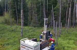
Accurate land measurements form the foundation of any successful project. Expert land surveying services focus on capturing detailed information about property boundaries, elevations, and existing site features. This data is essential for architects, engineers, and contractors who rely on it to design and execute their plans.
Without accurate survey information, projects may face issues such as misaligned structures, incorrect boundary assumptions, or design adjustments that could have been avoided. These problems often result in delays, additional costs, and unnecessary complications. Professional surveying helps prevent such situations by ensuring that all decisions are based on verified data.
Reducing Errors During Construction
One of the key ways expert land surveying services help prevent errors is through construction staking. Surveyors mark exact positions on the ground to guide the placement of buildings, roads, and utilities. This ensures that construction follows approved designs and stays within legal boundaries.
By clearly defining reference points on-site, surveyors help contractors work with confidence and precision. This reduces the likelihood of mistakes that might otherwise require corrections later in the project. Early accuracy leads to smoother execution and minimizes disruptions during construction.
Supporting Better Planning and Design
Expert land surveying services also contribute to improved planning and design. Topographic surveys provide detailed insights into the natural and built features of a site, including elevation changes and surface conditions. With this information, design teams can make informed decisions that align with the realities of the land.
Proper planning based on accurate survey data helps avoid unexpected challenges once construction begins. For example, understanding drainage patterns or ground conditions early on can prevent the need for major design changes later. This proactive approach supports efficiency and helps keep timelines intact.
Avoiding Delays in Approvals and Compliance
Surveying plays an important role in meeting regulatory requirements. Many projects require accurate land data for permits, approvals, and compliance with local guidelines. Expert land surveying services ensure that all necessary documentation is prepared according to professional standards.
When survey information is complete and reliable, the approval process tends to move more smoothly. This reduces the risk of delays caused by missing or incorrect data. In turn, projects can progress without unnecessary interruptions.
Ensuring Consistent Project Progress
By minimizing errors and supporting informed decision-making, expert land surveying services help maintain steady project progress. Accurate data at the start reduces the need for revisions, while precise on-site guidance keeps construction aligned with plans.
In environments where timelines and budgets are closely managed, avoiding delays is essential. Professional surveyors contribute to this by providing clarity at every stage of a project, from initial planning to final execution.
Building Confidence Through Professional Expertise
Working with experienced surveyors ensures that all aspects of land measurement and documentation are handled with care. Their expertise allows project teams to rely on accurate information and proceed with greater confidence.
By preventing errors and reducing the likelihood of delays, expert land surveying services provide lasting value. Their role may often be behind the scenes, but their impact is clearly visible in the smooth and successful completion of projects.
For More Information About Land Surveying Regina and Land Surveying Saskatoon Please Visit: Connexa Group.